Summary | Excerpt | Reviews | Beyond the Book | Read-Alikes | Genres & Themes | Author Bio

A Novel
by Charmaine WilkersonThis article relates to Black Cake
 In Charmaine Wilkerson's novel Black Cake, one of the main characters has made a career as an oceanographer, concentrating on mapping the ocean floor.
Water covers about 70% of the Earth's surface. And yet surprisingly little is known about what lies beneath it; just a little over 20% of the seabed had been mapped as of 2021. It's long been understood that being aware of the shape of the sea floor, particularly near a coast, is helpful for navigation, and this knowledge has become critical for laying underwater cables and pipelines as well. Understanding the shape of the land beneath the ocean's surface can also be useful for predicting hazards such as tsunamis as well as climate change projections. It can additionally be helpful for monitoring the habitats of marine animals, and for the management of oil, gas and minerals.
In the past, people relied on a technique called sounding to check water depth, particularly near land. A weighted rope was lowered into the water and a measurement taken when it went slack, thereby determining how far down the seabed was. This method is crude, though, only providing limited information about the shallowest parts of the ocean.
The projection of underwater sound waves, known as sonar (an acronym for "sound navigation and ranging"), was developed during World War I. This technology was used as a way of locating enemy submarines by measuring distance through the amount of time it took for sound pulses to bounce off of the underwater objects and return. After the war, the technology was adopted by the Coast and Geodetic Survey (a precursor of the National Oceanic and Atmospheric Administration, aka NOAA) to produce the first seabed maps. 1957 saw the publication of the Physiographic Map of the North Atlantic — the first map that allowed the public to see what the ocean floor really looked like. Sonar use also led to a revolution in the study of plate tectonics and an increased understanding of how geological features were formed. The process was still cumbersome, however, requiring many individual sonar soundings to be manually pieced together to form a full picture.
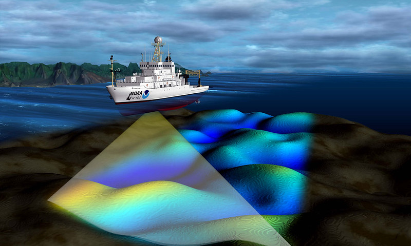
In the 1960s, the United States Navy developed technology known as multibeam sonar that produced soundings over a wider area. It provided greater detail in addition to simply being more efficient. The Navy released the technology to the scientific community in the late 1970s, and it remains the primary means of mapping the ocean floor today. Multibeam sonar also measures the intensity of the returning pulse, which produces information about the makeup of the seabed. Mud, for example, absorbs most of the sound, bouncing very little back to the receiver, while rock doesn't absorb much at all. Sidescan sonar, which allows equipment lowered on a cable to capture a wider area of the ocean floor, is used to supplement information obtained via multibeam. Despite the advantages of sonar, there are concerns about its detrimental effects, as it can be harmful to marine life.
Multiple efforts have been launched aiming to produce a complete, accurate map set of the ocean floor, the most well-known of which is the Seabed 2030 Project, operated by the Nippon Foundation and GEBCO (General Bathymetric Chart of the Oceans). When the project started in 2017, just 6% of the sea floor had been mapped. By 2021, that figure had risen to 20.6%. General opinion is that their goal of compiling a map of the ocean floor by 2030 is ambitious, particularly in light of slowdowns precipitated by the COVID-19 pandemic.
The Seabed 2030 Project isn't the only venture collecting data on the ocean floor, however. Olex in Norway, for example, uses crowdsourcing to gather data from fishing trawlers. The DSSV Pressure Drop, a ship owned by Texas billionaire Victor Vescovo, mapped an area the size of Italy over the course of just 10 months, covering areas that had never been documented. In addition, advances in science are developing new means of collecting data. A Japanese research lab is outfitting stingrays with "pinger technology" and digital cameras to allow the sea animals to produce maps, a technique that has proven quite accurate in testing.
Ship collecting multibeam sonar data, courtesy of NOAA's National Ocean Service photostream (CC BY 2.0)
Filed under Nature and the Environment
![]() This "beyond the book article" relates to Black Cake. It originally ran in April 2022 and has been updated for the
February 2022 edition.
Go to magazine.
This "beyond the book article" relates to Black Cake. It originally ran in April 2022 and has been updated for the
February 2022 edition.
Go to magazine.
Your guide toexceptional books
BookBrowse seeks out and recommends the best in contemporary fiction and nonfiction—books that not only engage and entertain but also deepen our understanding of ourselves and the world around us.